The use of remote sensing technology in the study and management of fisheries is growing. Remote sensing offers a variety of advantages over traditional methods.
This article will explore how satellite imagery can be used to monitor and manage large-scale fisheries operations that would otherwise be impossible.

Applications of Remote Sensing in Fisheries
Some of the key applications of remote sensing in fisheries include:
Stock Assessment | Mapping Fish Distribution

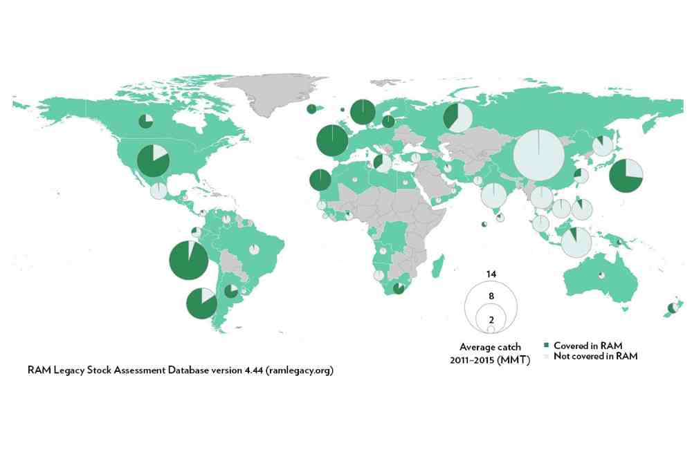
Stock assessment is the process of determining the size and health of a fish population. This information is used to manage and conserve fish populations, and to ensure sustainable fishing practices.
Stock assessment is important for the management of fish populations worldwide, as it helps to ensure that fishing is sustainable and does not lead to the overfishing of a particular species.
Remote sensing can help in stock assessment of fish worldwide by providing a cost-effective and efficient way to collect data on large areas of ocean and coastal waters.
Remote sensing data can be used to identify and map different types of fish habitats, such as coral reefs, estuaries, and coastal wetlands.
This information can then be used to identify areas that are important for fish and other aquatic species.
In stock assessment, remote sensing data can be used to estimate the distribution, abundance and biomass of fish populations.
Remote sensing data can be used to track fish migration patterns and to monitor changes in fish populations over time.
This information can be used to inform management decisions and to help ensure that fishing is sustainable.
Remote sensing can also be used to detect and monitor oceanic phenomena such as ocean currents and temperature changes which can affect the distribution of fish populations.
In addition to the traditional method of stock assessment which is based on sample collections and surveys, remote sensing can provide a cost-effective alternative for fish stock assessment, especially for pelagic species which are difficult to sample.
Remote sensing can also provide data that can be used to validate and improve the traditional methods of stock assessment.
Habitat Mapping
Habitat mapping is the process of identifying, describing and mapping the different types of habitats present in a specific area.
This information is used for a variety of purposes, including conservation, land-use planning, and resource management.
This process providing a cost-effective and efficient way to collect data on large areas of land and water that are important for fish and other aquatic species.
In fish habitat mapping, remote sensing data is used to identify and map different types of aquatic habitats, such as wetlands, estuaries, rivers, and lakes.
These data can also be used to monitor changes in habitats over time, such as the effects of human activities or natural disasters, which can be used to inform conservation and management strategies.
Physical and biological characteristics of marine and freshwater habitats can be visualized through mapping, which are critical for the survival and reproduction of fish.
This is done by using satellites to detect changes in the water’s surface temperature, which can indicate the presence of schools of fish.
Remote sensing can help identify areas that are important for fish spawning or feeding. This information can be used to develop plans for sustainable fishing practices.
It identify areas where fishing would be most productive, by measuring factors such as water depth, salinity, and the concentration of plankton.
Ocean Monitoring
Remote sensing can be used to monitor ocean conditions such as temperature, salinity, and currents, which can have a major impact on fish populations.
Ocean monitoring is the process of measuring and analyzing various physical, chemical, and biological parameters of the ocean.
This information is used to understand the health and functioning of marine ecosystems, as well as to monitor changes in the ocean environment.
Remote sensing data can be used to create detailed maps of ocean features such as temperature, currents, oxygen level, salinity, and chlorophyll concentrations, which can provide information about ocean health and productivity.
These data can be used to understand ocean circulation patterns, detect oceanic fronts, and track the movement of ocean currents.
These data can also be used to monitor changes in the ocean environment, such as the effects of climate change and ocean acidification, which can be used to inform conservation and management strategies.
Remote sensing can provide synoptic and continuous coverage of the ocean, which is difficult or impossible to achieve by traditional in-situ methods, also it can provide large scale data that can be used to detect and monitor oceanic phenomena such as El Nino, La Nina and oceanic gyres, which are important for ocean circulation, weather forecasting, and marine life.
Bycatch Reduction
Bycatch is the accidental capture of non-target species in fishing gear. It refers to fish, marine mammals, sea turtles, and other marine species that are caught unintentionally while fishing for a different species.
Bycatch can have significant impacts on marine ecosystems, as it can lead to the overfishing of non-target species and the destruction of important marine habitats.
Remote sensing can be used to identify bycatch in fishing by detecting and monitoring the activities of fishing vessels and the impacts of fishing on marine habitats.
For example, satellite imagery can be used to identify areas of seafloor that have been damaged by bottom trawling, which is a fishing method that can result in high levels of bycatch.
Remote sensing data can also be used to detect the presence of ghost fishing gear, which can continue to trap and kill marine life even after it is abandoned by fishers.
Illegal Fishing Detection
Illegal, unreported, and unregulated (IUU) fishing is the fishing of fish in violation of national or international laws.
This can include fishing in protected areas, using prohibited fishing gear, catching protected species, and failing to report catches.
Illegal fishing is a major problem worldwide, as it can lead to overfishing, the depletion of fish stocks, and the destruction of marine habitats.
Remote sensing data can be used to identify illegal fishing worldwide by detecting and monitoring the activities of fishing vessels.
Remote sensing data, such as satellite imagery and Automatic Identification System (AIS) data, can be used to track the movement of fishing vessels and to detect illegal fishing activities.
For example, satellite imagery can be used to identify vessels that are fishing in protected areas or using prohibited gear.
AIS data can be used to detect vessels that are operating in areas where they should not be or vessels that are not reporting their location or activities.
This can be done by tracking the movement of boats, or by using sensors to detect the sound of fishing nets being dragged along the bottom of the ocean.
According to the Food and Agriculture Organization of the United Nations (FAO), illegal fishing accounts for 15-31% of global catch, which is valued at $10-23 billion annually.
The World Wildlife Fund (WWF) estimates that up to 26 million tons of fish are caught illegally each year, which is worth about $23 billion.
In addition, illegal fishing can also have significant economic impacts on legal fishers and the communities that depend on fishing for their livelihoods.
Remote sensing and modern technology such as Artificial Intelligence and Machine Learning can aid in detecting and identifying illegal fishing activities.
However, it also requires collaboration and coordination between different countries, organizations and stakeholders to effectively monitor and combat illegal fishing activities.
Identify Environmental Damage
Remote sensing can be used to identify environmental damage due to fishing activity in the ocean by detecting and monitoring the impacts of fishing on marine habitats.
For example, satellite imagery can be used to identify areas of seafloor that have been damaged by bottom trawling, or to detect the presence of ghost fishing gear, which can continue to trap and kill marine life even after it is abandoned by fishers.
These data can provide information about the health of coral reefs, mangroves, and other important marine habitats, which can be used to identify areas that are at risk of damage due to fishing activities.
In recent years, there has been growing awareness about the impacts of fishing on ocean ecosystems and the importance of sustainable fishing practices.
Remote sensing data can be used to monitor fishing activities and to identify areas where conservation efforts are needed.
Overall, remote sensing is a powerful tool for managing and conserving fish stocks, and it can play a critical role in ensuring the long-term sustainability of the world’s fisheries.
